Drone photography transforms Somerset property listings by showing land boundaries, outbuildings, surrounding countryside, and the property's setting in context. It's particularly valuable for rural properties, farms, equestrian properties, and homes with large gardens. I fly a sub-250g drone in the Open Category, meaning I can safely and legally access most areas. I offer drone photography as an add-on from £79, covering all of Somerset, Bristol, and Bath.
Somerset's landscape is one of its greatest selling points. From the Quantock Hills to the Somerset Levels, from the Mendips to the Blackdown Hills, properties here sit within some of England's most beautiful countryside. Drone photography captures this context in a way that ground-level photography simply cannot.
01Why Somerset Properties Benefit from Drone Photography
When you're selling a property in Somerset, you're not just selling bricks and mortar. You're selling the view from the kitchen window, the walk to the village pub, the proximity to open countryside. Ground-level photography shows what a property looks like. Drone photography shows where it is and what surrounds it.
For rural Somerset properties, this is particularly important. A farmhouse might sit on five acres with views across the Levels. A village cottage might back onto open fields. A barn conversion might be surrounded by rolling hills. None of this is visible from ground level, but from 30 metres up, the full picture becomes clear.
I include drone photography in every package from £149 because I believe it's essential for Somerset properties, not an optional extra.
02What Drone Photography Shows That Ground-Level Can't
Property Boundaries and Land
For properties with significant land, drone photography is the only way to show the full extent of the plot. Buyers can see:
- The exact boundaries of the property
- The relationship between the house, garden, and any outbuildings
- Access routes and driveways
- Neighbouring properties and privacy levels
- The condition of the land (paddocks, orchards, woodland)
Location and Context
Somerset buyers often choose a property as much for its location as for the building itself. Drone shots reveal:
- Distance to the nearest village or town
- Proximity to open countryside, footpaths, or bridleways
- Views that the property enjoys
- Transport links and road access
- Nearby amenities (schools, shops, pubs)
Roof Condition and Building Layout
From above, buyers can assess:
- Roof condition (particularly important for older Somerset properties)
- Solar panel placement and potential
- Extension possibilities
- The overall footprint and layout of the building
- Any outbuildings, garages, or annexes
03Legal Requirements for Drone Photography in Somerset
As a CAA-registered drone operator flying in the Open Category with a sub-250g drone, I operate within all UK regulations. Here's what you need to know:
Flight restrictions: Drones cannot be flown within flight restriction zones (FRZs) around airports, or within certain distances of people, buildings, and vehicles that aren't under the pilot's control. Most rural Somerset properties have no restrictions, but some properties near Yeovilton, Bristol Airport, or Hinkley Point may have limitations.
Permission: For properties in built-up areas (town centres, housing estates), I may need to operate under specific operational authorisations. I handle all of this as part of the booking process, so you don't need to worry about it.
Weather: Drones can't fly in heavy rain, strong winds (above 20mph), or fog. Somerset's weather can be changeable, so I always have a backup plan. If conditions aren't suitable on the day, I'll return at no extra charge.
04Types of Drone Shots for Somerset Properties
The Overview Shot
Taken from 30-50 metres, this shows the property in its full context. It's the shot that makes buyers say "wow" and immediately understand what makes the property special. For Somerset properties, this often reveals the surrounding countryside, nearby villages, and the property's relationship to the landscape.
The Elevated Angle
Taken from 10-20 metres at a 45-degree angle, this shows the property from a perspective that's impossible from ground level but still feels natural. It's excellent for showing garden layout, parking, and the building's overall form.
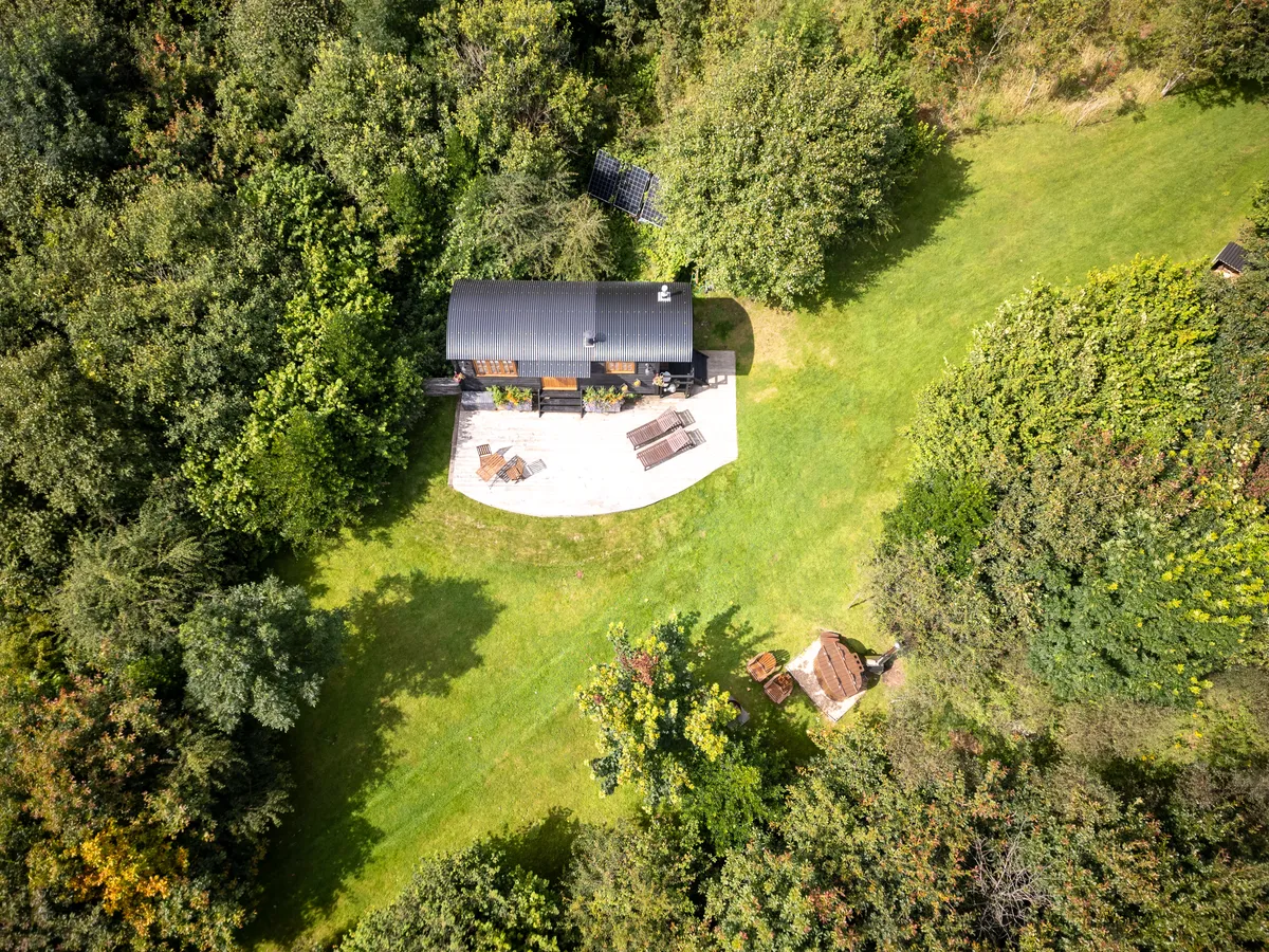
The Bird's Eye
Taken directly above the property, this is essentially an aerial plan view. It's particularly useful for properties with complex layouts, multiple buildings, or significant land. Buyers can see exactly how the property is arranged.
The Approach Shot
Taken from a distance, flying towards the property, this creates a sense of arrival and shows the property in its wider setting. It's particularly effective for properties accessed via long driveways or those set within larger estates.
05Drone Photography for Different Somerset Property Types
Farmhouses and Rural Properties
Somerset's farmhouses are often the properties that benefit most from drone photography. A ground-level shot shows a nice stone building; a drone shot reveals the five acres of paddock, the views across the Levels, and the fact that the nearest neighbour is half a mile away.
Village Properties
Even in Somerset's villages, drone photography adds value. It shows proximity to the church, the pub, the village green. It shows whether the garden backs onto fields or other houses. It gives context that ground-level photography simply can't provide.
Coastal Properties
For properties near the Somerset coast (Minehead, Watchet, Burnham-on-Sea), drone photography can show proximity to the sea, coastal paths, and the dramatic Somerset coastline.
Development Sites
For developers working in Somerset, drone photography is essential for showing the full extent of a site, its access routes, and its relationship to surrounding infrastructure. I work with several Somerset developers who use drone photography for planning applications as well as marketing.
06How Drone Photography Fits Into My Packages
Unlike many photographers who charge extra for drone work, I include it in every package:
| Package | Price | Ground Photos | Drone Photos | Total |
|---|---|---|---|---|
| Essential | £149 | Up to 12 | 3-5 | Up to 15 |
| Professional | £199 | Up to 16 | 4-6 | Up to 20 |
| Premium | £299 | Up to 24 | 6-8 | Up to 30 |
The exact split between ground and drone photos depends on the property. A rural farmhouse might benefit from more drone shots, while a town-centre flat might only need one or two aerials.
07Somerset Areas I Cover with Drone Photography
I cover all of Somerset and the surrounding areas for drone photography:
- Taunton and West Somerset: Including Minehead, Wellington, Watchet
- Bridgwater and the Levels: Including Burnham-on-Sea, Highbridge, Glastonbury
- Mendip: Including Wells, Shepton Mallet, Frome, Cheddar
- South Somerset: Including Yeovil, Chard, Ilminster, Langport
- Bristol and Bath: Including all surrounding villages and towns
View my full drone photography services or my Somerset property photography page.
08Tips for Getting the Best Drone Shots
If you're preparing your Somerset property for a photography shoot that includes drone work:
- 1.Mow the lawn: It's amazing how much better a property looks from above when the grass is neat
- 2.Tidy the garden: Remove any eyesores, dead plants, or clutter
- 3.Move cars: Park vehicles away from the property if possible
- 4.Check the roof: Remove any moss, debris, or visible damage if you can
- 5.Clear the driveway: A clean, clear approach looks much better from above
Drone photography included in every package from £149. Covering all of Somerset, Bristol, and Bath. View my drone photography services or get in touch to discuss your property.
UK Drone Restricted Zones Map
This is a rough guide only showing 138 of the major restricted zones across the UK. It does not include every no-fly zone, there are many more local restrictions, temporary NOTAMs, and event-specific zones that aren't shown here. For the full and most up-to-date picture, I'd recommend checking NoFlyDrones.co.uk and the official NATS restriction zone map before every flight.
This is a rough guide only. This map shows the major restricted zones but it doesn't include everything, there are hundreds of smaller restrictions, temporary NOTAMs, Temporary Danger Areas, and event-specific zones that aren't shown here. The boundaries shown are approximate circles; in reality, many FRZs are elongated along runway centrelines.
Always check official sources before you fly. I'd recommend NoFlyDrones.co.uk for a comprehensive interactive map, the NATS restriction zone map for official FRZ data, and the Drone Safety Map by Altitude Angel. Since January 2024, all closed prisons and young offender institutions in England and Wales also have 400m drone restricted airspace.